← Home · Geophysics

Electrical Resistivity Surveys – Vertical Electrical Sounding in West Valley City

Together, we solve the challenges of tomorrow.

LEARN MORE →

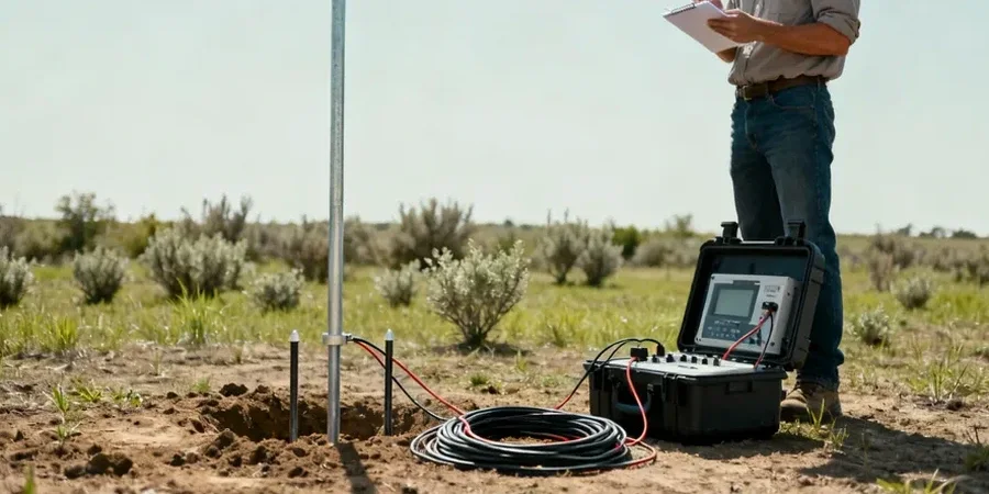
West Valley City sits on the edge of ancient Lake Bonneville. The lake left behind thick lacustrine clays and silts, interspersed with sand lenses from the Oquirrh Mountain alluvial fans. These deposits create a tricky electrical signature. Clay conducts. Sand resists. Fresh groundwater masks deep boundaries. A standard drilling program can miss the lateral changes. We use Vertical Electrical Sounding (VES) to map these contrasts fast. The method injects current and measures potential. Resistivity values build a 1D profile of the subsurface. For foundation design or groundwater exploration in the 23-square-mile city, the electrical resistivity approach cuts uncertainty before the first excavator bucket hits the ground.

In Bonneville basin sediments, a 10-ohm shift in resistivity often signals the transition from stiff clay to loose silt – a boundary that controls settlement.

Process and scope

We typically deploy the Schlumberger array across the Jordan River corridor and near the Decker Lake basin. Expanding electrode spacing from 1.5 meters out to 200 meters lets us resolve layering down to 100 feet. The saturated Bonneville clays read below 15 ohm-m. Dry granular lenses jump above 80 ohm-m. Bedrock contact at depth shows a sharp gradient. Our field crew logs each sounding with GPS coordinates tied to the West Valley City GIS grid. Data inversion runs twice – once with a smooth model, once with a blocky model – to bracket the true stratigraphy. The final deliverable includes resistivity cross-sections, interpreted layer thicknesses, and a correlation table with nearby boring logs when available. We deliver within five business days for standard lots.
Electrical Resistivity Surveys – Vertical Electrical Sounding in West Valley City
Technical reference image — West Valley City

Local geotechnical context

We see the same mistake on infill lots near 3500 South. The builder assumes uniform clay. They skip geophysics. Footings go in. Differential settlement appears within two years. The real culprit is a discontinuous sand channel 12 feet down – invisible in a single boring but obvious on a VES profile. Sand drains differently than clay. It compacts under load. The resistivity contrast between 8 ohm-m clay and 120 ohm-m sand is impossible to miss if you sound the site. Another common problem in West Valley City: buried organic lenses from old marsh deposits near the Jordan River. These read as ultra-low resistivity zones. A drill rig might punch through without sampling them. VES flags the anomaly and prompts targeted sampling. The cost of the survey is trivial compared to litigation.

Need a geotechnical assessment?

Reply within 24h.

Email: info@geotechnicalengineering.sbs

Technical parameters

ParameterTypical value
Array typeSchlumberger (standard), Wenner (optional)
Max investigation depth100-130 ft with AB/2 = 200 ft
Typical resistivity range3 ohm-m (saturated clay) to 300+ ohm-m (dry gravel)
Measurement points per sounding18-25 per decade of spacing
Data processing1D inversion, smooth and block models
ReportingResistivity vs. depth curves, interpreted stratigraphic columns

Other technical services

01

Deep VES for Foundation Design

Schlumberger soundings to 100+ feet. We map clay-sand-bedrock interfaces for commercial buildings and multifamily projects. Report includes interpreted layer thicknesses tied to IBC presumptive bearing values.

02

Groundwater and Contamination VES

Shallow soundings focused on the water table and plume boundaries. Used for Phase II ESA follow-up. We correlate resistivity with fluid conductivity to outline impacted zones.

Applicable standards

ASTM D6431-18 Standard Guide for Using the Direct Current Resistivity Method, ASCE 7-22 Minimum Design Loads and Associated Criteria, IBC 2021 Chapter 18 Soils and Foundations, USGS Professional Paper 1584 – Bonneville Basin Stratigraphy

Common questions

How much does a VES survey cost for a standard residential lot in West Valley City?

A typical single-family lot with four soundings runs between US$620 and US$1,030 total. The price depends on maximum depth, array length, and access constraints. We include data processing and a signed report.

How deep can you see with electrical resistivity?

Depth is controlled by the current electrode spacing. With AB/2 = 200 feet, we routinely resolve layers to 100-130 feet in Bonneville basin sediments. Deeper is possible with longer spreads if the site allows.

Can VES tell the difference between clay and silt?

Yes, if the porosity and saturation differ. Bonneville clays typically read 5-15 ohm-m when wet. Silts range 20-40 ohm-m. The contrast is clear. We calibrate against nearby boring logs whenever possible.

How long does the field work take?

Four soundings on a quarter-acre lot take about three to four hours with a two-person crew. We work around existing structures and underground utilities. Reporting takes five business days.

Location and service area

We serve projects in West Valley City and surrounding areas.

View larger map